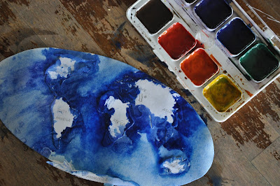
Map Monday: World Water Map
Little drops of water,
Little grains is sand.
Make the mighty ocean,
And the pleasant land.
Thus the little minutes,
Humble though they be,
Make the mighty ages
Of Eternity.
~Isaac Watts
Little grains is sand.
Make the mighty ocean,
And the pleasant land.
Thus the little minutes,
Humble though they be,
Make the mighty ages
Of Eternity.
~Isaac Watts
Being Earth Week, we're taking a day of this week to look at water, fire, soil and air.
We've done this sort of 'relief' map before, cutting out continent stencils.
Today we solely painted the water, to take a good look at how much of it covers Planet Earth.
If your children are young, you can prepare by tracing a map of the world and having them cut out the continents. Older children may want to trace or draw their own version, which is a good way to examine land mass, make size comparisons and determine positions on the globe.
Once the continents are ready, your children can lightly tape on the stencils before painting around the continents.
Naturally watercolour paint works really well to depict water.
You can heavily outline the continents and use a wet brush to drag the paint.
Once work is dry, you can peel away the stencils to reveal a beautiful map.
We then marked the five oceans: Pacific, Atlantic, Indian, Southern and Arctic.
What a fantastic book for your geography collection!
Giant, beautiful illustrations depict a variety of countries and mini drawings give bits of information about the culture including language, food, nature, biology and history.
Instantly made the book wish list.


